


Details
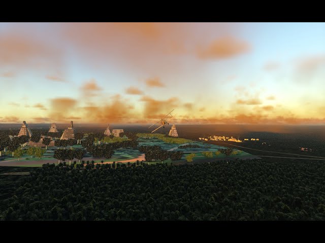
Tikal is an archaeological center of the Mayan civilization in Guatemala. All the main temples and piramidal structures are represented in this scenery. Also the entrance and the museums around are located at the scenery. Start the tour at the Uaxactun airfield North of Tikal. To get to Tikal, follow the road line with the ceiba trees that stand out from the jungle due to their height. Following the road some small towns are located with some typical houses and churches. When you get to Tikal, the road continues to Lake Peten-Itza. Arriving to the city of Flores where the “El Mundo Maya Intl Airport” is. Flores is represented with some buildings, the Peten hotel and its cathedral, churches and several more buildings. The Latitud and Longitud of Tikal in case you go directly for the position is: 17.21451° north, -89.61447° west. The scenery run in X-Plane 12/11 and for Windows ( XP12 v 12.1.3 ). Thomas Krumins designer.
Features:
Costumized the main 7 temples of Tikal with piramidal shape:
1- The Great Jaguar Temple.
2- The Two Masks Temple.
3- The Jaguar Priest.
4- The Two-Headed Smake
5- Temple V
6- Temple of the Inscriptions.
7- Pyramid of Lost World
Costumized piramidal structures and buildings in Tikal.
Central Acropolis
North Acropolis
Maler’s Palace
Central Plaza with altars and more structures
Hotel Peten at Flores Island
Hotels and Museums in Tikal
Hotel Tikal bungalows
Museum of Sylvanus Morley
Museo del Mundo Maya
Buildings and houses of small villages from Uaxactun to Flores following the road with ceiba trees.
Several Churches and one Cathedral in Flores.
The trees, in special the ceiba tall tree typical of the jungle.
All the trees are original, made in 3D models. Except the default trees of the scenery
The objects are made with Blender. The original buildings have textures in the façades with photos taken from the place.
Important to have the file: +10-100/+16-092.dsf of this part of the world Guatemala.
Tags
Requirements
X-Plane 12 and X-Plane 11. For Windows in v. 12.1.3
Recommended Products
€ 15.49
$
USD 17.66
All sales based on Euro. Other currencies shown as reference only.£
GBP 13.27
All sales based on Euro. Other currencies shown as reference only.¥
CNY 119.87
All sales based on Euro. Other currencies shown as reference only.
€ 5.20
$
USD 5.93
All sales based on Euro. Other currencies shown as reference only.£
GBP 4.45
All sales based on Euro. Other currencies shown as reference only.¥
CNY 40.24
All sales based on Euro. Other currencies shown as reference only.
9.49
€ 6.64
$
USD 10.82
All sales based on Euro. Other currencies shown as reference only.£
GBP 8.13
All sales based on Euro. Other currencies shown as reference only.¥
CNY 73.44
All sales based on Euro. Other currencies shown as reference only.
-30%
30-day price low:
€
9.49

€ 7.99
$
USD 9.11
All sales based on Euro. Other currencies shown as reference only.£
GBP 6.84
All sales based on Euro. Other currencies shown as reference only.¥
CNY 61.83
All sales based on Euro. Other currencies shown as reference only.
€ 8.00
$
USD 9.12
All sales based on Euro. Other currencies shown as reference only.£
GBP 6.85
All sales based on Euro. Other currencies shown as reference only.¥
CNY 61.91
All sales based on Euro. Other currencies shown as reference only.
€ 7.99
$
USD 9.11
All sales based on Euro. Other currencies shown as reference only.£
GBP 6.84
All sales based on Euro. Other currencies shown as reference only.¥
CNY 61.83
All sales based on Euro. Other currencies shown as reference only.
€ 19.99
$
USD 22.79
All sales based on Euro. Other currencies shown as reference only.£
GBP 17.12
All sales based on Euro. Other currencies shown as reference only.¥
CNY 154.70
All sales based on Euro. Other currencies shown as reference only.
€ 0.00
$
USD 0.00
All sales based on Euro. Other currencies shown as reference only.£
GBP 0.00
All sales based on Euro. Other currencies shown as reference only.¥
CNY 0.00
All sales based on Euro. Other currencies shown as reference only.