限时发售!
天
小时
分钟
秒
-30%
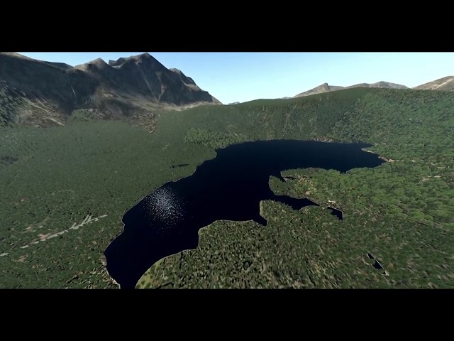
MeshXP Germany is compiled using 30 m resolution elevation models. Hydrological scenery is completely rebuilt using the latest osm data and with better shaped shorelines and waters. It can be used on its own or underneath photorealistic scenery. Use Xplane 11 default Vectors ie roads, landlass. This is an xp11 terrain mesh. All MeshXP packages are designed to fit into each over to provide continuous coverage. All MeshXP scenery work in Windows and Mac.
模拟平台:X-Plane 11
CPU:Intel Core i5 6600K 3.5 Ghz+ 主频
内存:16 GB
显卡:支持 DirectX 12 - 4 GB显存
硬盘:938 MB 可用空间

10.99
USD 12.61
所有商品的售价基准为欧元,其他货币价格仅供参考!GBP 9.51
所有商品的售价基准为欧元,其他货币价格仅供参考!CNY 86.98
所有商品的售价基准为欧元,其他货币价格仅供参考!
USD 25.03
所有商品的售价基准为欧元,其他货币价格仅供参考!GBP 18.87
所有商品的售价基准为欧元,其他货币价格仅供参考!CNY 172.62
所有商品的售价基准为欧元,其他货币价格仅供参考!
10.99
USD 12.61
所有商品的售价基准为欧元,其他货币价格仅供参考!GBP 9.51
所有商品的售价基准为欧元,其他货币价格仅供参考!CNY 86.98
所有商品的售价基准为欧元,其他货币价格仅供参考!
10.99
USD 12.61
所有商品的售价基准为欧元,其他货币价格仅供参考!GBP 9.51
所有商品的售价基准为欧元,其他货币价格仅供参考!CNY 86.98
所有商品的售价基准为欧元,其他货币价格仅供参考!
17.99
USD 20.65
所有商品的售价基准为欧元,其他货币价格仅供参考!GBP 15.56
所有商品的售价基准为欧元,其他货币价格仅供参考!CNY 142.38
所有商品的售价基准为欧元,其他货币价格仅供参考!
9.99
USD 11.46
所有商品的售价基准为欧元,其他货币价格仅供参考!GBP 8.64
所有商品的售价基准为欧元,其他货币价格仅供参考!CNY 79.07
所有商品的售价基准为欧元,其他货币价格仅供参考!15.99
USD 18.35
所有商品的售价基准为欧元,其他货币价格仅供参考!GBP 13.83
所有商品的售价基准为欧元,其他货币价格仅供参考!CNY 126.55
所有商品的售价基准为欧元,其他货币价格仅供参考!
11.99
USD 13.76
所有商品的售价基准为欧元,其他货币价格仅供参考!GBP 10.37
所有商品的售价基准为欧元,其他货币价格仅供参考!CNY 94.89
所有商品的售价基准为欧元,其他货币价格仅供参考!