


Details
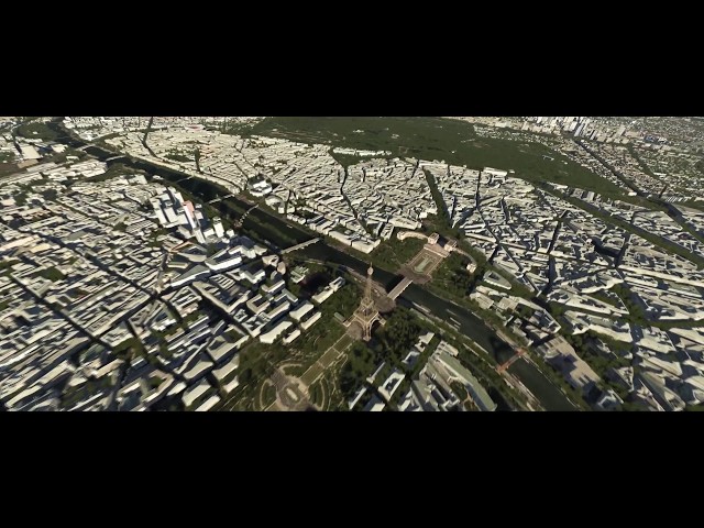
Paris-Ile-de-France is a photo-realistic addon produced by France VFR for Aerofly FS 2. The scenery depicts the city of Paris with its main monuments, its bridges and its suburbs as well as the entire Ile de France region.
The scenery includes coverage of aerial images and high-resolution terrain mesh, thousands of VFR landmarks, aeronautical obstacles and remarkable and buildings, several million buildings and trees and three highly detailed airports.
The new VFR Regional series was designed and developped to provide VFR flight an environment as realistic as possible. It is the result of years of experience and practice in flight simulation and 3D modeling.
"VFR Regional" products embed all enhancements from the new 3DAutomation® technology developed by France VFR. This technology already allows to generate the most realistic and dense environments ever seen. It does not intend to model real world accurately but to create a copy "as real as it gets" on a massive scale. It will evolve to adapt to the needs and new data available.
- Paris-Ile de France region depicted in complete detail.
- Ground textures from 0.25 to 1.60 meter/pixel resolution from IGN aerial photography reworked for an optimal visual rendering.
- Ultra HD mesh 4.75 meters resolution over the entire scenery.
- Obstacles and VFR landmarks modeled on the entire scenery including the official SIA database (antennas, towers, water towers, wind turbines, various constructions ...).
- Thousands of objects and POI buildings integrated into the environment (churches, power plants, silos, castles, industrial tanks, bridges, tolls...).
- Lognes, Saint-Cyr and Toussus airports modeled in great details.
- CDG, Orly and Le Bourget airports aren't fully modelled as operational airports but runway textures have been flattened and main buildings are featured.
- External photo-realistic coverage outside the Paris-Ile de France area for better transition.
- Integration of 3D Automation® technology allowing multi-million buildings and realistic vegetation areas fitting geographic specifications.
- Extremely dense vegetation cultivation from high resolution IGN data.
- Full 3D night lighting on the entire scenery.
- Geo-referenced data for maximum compatibility with future add-ons installed on the same area.
标签
其他可选

€ 16.58
$
USD 19.42
所有商品的售价基准为欧元,其他货币价格仅供参考!£
GBP 14.44
所有商品的售价基准为欧元,其他货币价格仅供参考!¥
CNY 132.59
所有商品的售价基准为欧元,其他货币价格仅供参考!使用需求
IPACS Aerofly FS2
购买了该商品的顾客还买了
€ 14.99
$
USD 17.55
所有商品的售价基准为欧元,其他货币价格仅供参考!£
GBP 13.06
所有商品的售价基准为欧元,其他货币价格仅供参考!¥
CNY 119.87
所有商品的售价基准为欧元,其他货币价格仅供参考!
€ 12.99
$
USD 15.21
所有商品的售价基准为欧元,其他货币价格仅供参考!£
GBP 11.31
所有商品的售价基准为欧元,其他货币价格仅供参考!¥
CNY 103.88
所有商品的售价基准为欧元,其他货币价格仅供参考!
€ 12.99
$
USD 15.21
所有商品的售价基准为欧元,其他货币价格仅供参考!£
GBP 11.31
所有商品的售价基准为欧元,其他货币价格仅供参考!¥
CNY 103.88
所有商品的售价基准为欧元,其他货币价格仅供参考!
€ 10.99
$
USD 12.87
所有商品的售价基准为欧元,其他货币价格仅供参考!£
GBP 9.57
所有商品的售价基准为欧元,其他货币价格仅供参考!¥
CNY 87.88
所有商品的售价基准为欧元,其他货币价格仅供参考!
€ 13.99
$
USD 16.38
所有商品的售价基准为欧元,其他货币价格仅供参考!£
GBP 12.19
所有商品的售价基准为欧元,其他货币价格仅供参考!¥
CNY 111.87
所有商品的售价基准为欧元,其他货币价格仅供参考!
€ 24.92
$
USD 29.18
所有商品的售价基准为欧元,其他货币价格仅供参考!£
GBP 21.71
所有商品的售价基准为欧元,其他货币价格仅供参考!¥
CNY 199.28
所有商品的售价基准为欧元,其他货币价格仅供参考!
€ 33.25
$
USD 38.94
所有商品的售价基准为欧元,其他货币价格仅供参考!£
GBP 28.96
所有商品的售价基准为欧元,其他货币价格仅供参考!¥
CNY 265.89
所有商品的售价基准为欧元,其他货币价格仅供参考!
€ 24.92
$
USD 29.18
所有商品的售价基准为欧元,其他货币价格仅供参考!£
GBP 21.71
所有商品的售价基准为欧元,其他货币价格仅供参考!¥
CNY 199.28
所有商品的售价基准为欧元,其他货币价格仅供参考!